Build an ATS-Friendly
Earth Observation Space Scientist Resume
That Gets Interviews
Harnessing advanced satellite technologies, Earth Observation Space Scientists decode crucial planetary data into actionable insights for environmental and climate applications. Collaborating with governance bodies and research institutions, they analyze vast datasets such as multispectral imagery to track changes in…
Earth Observation Space Scientist Resume Templates
Modern Professional
Use Template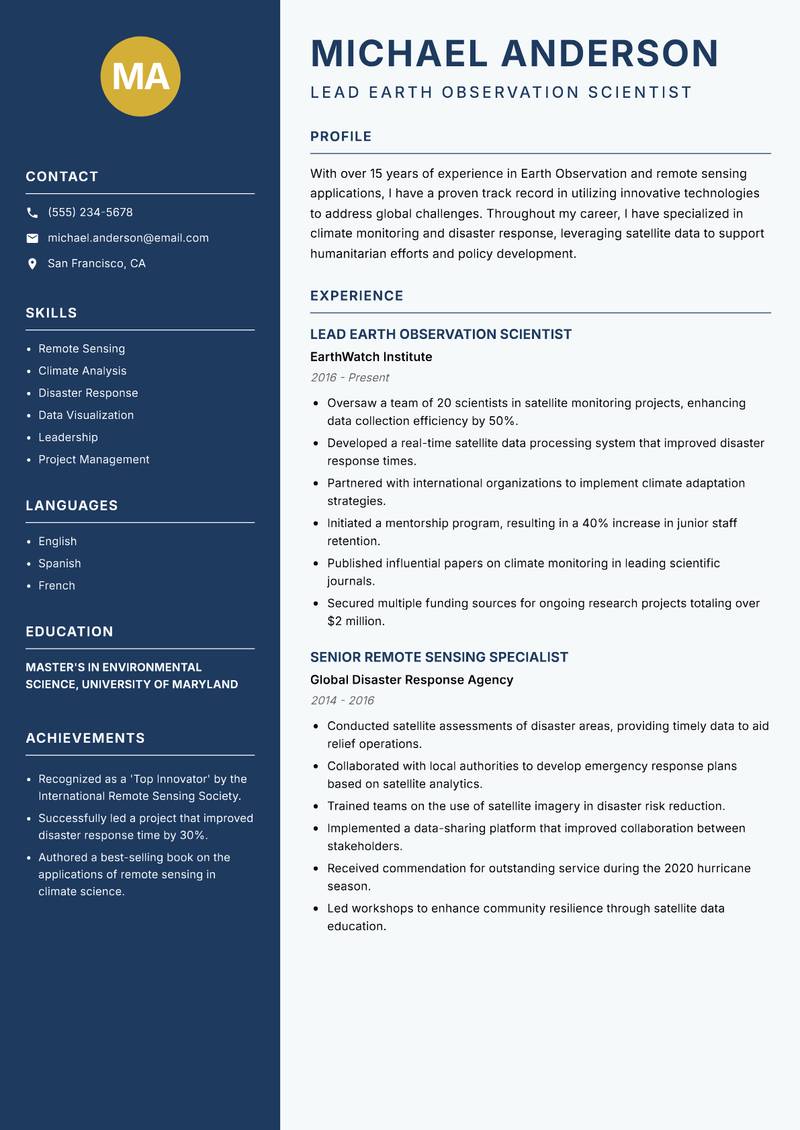
Classic Clean
Use Template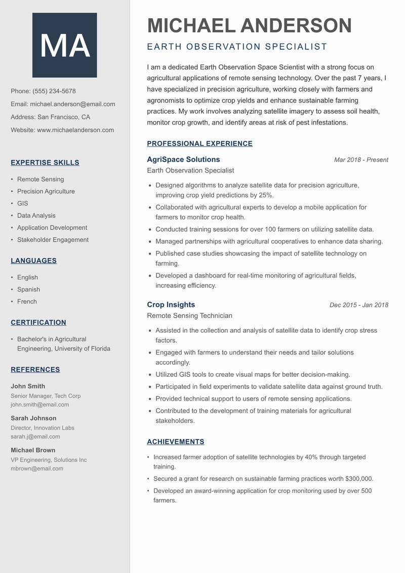
Creative Minimal
Use Template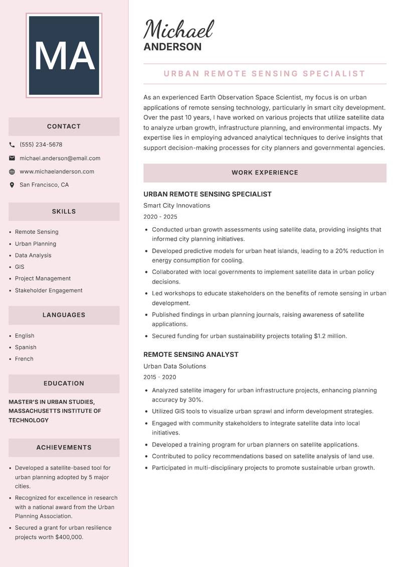
Executive
Use Template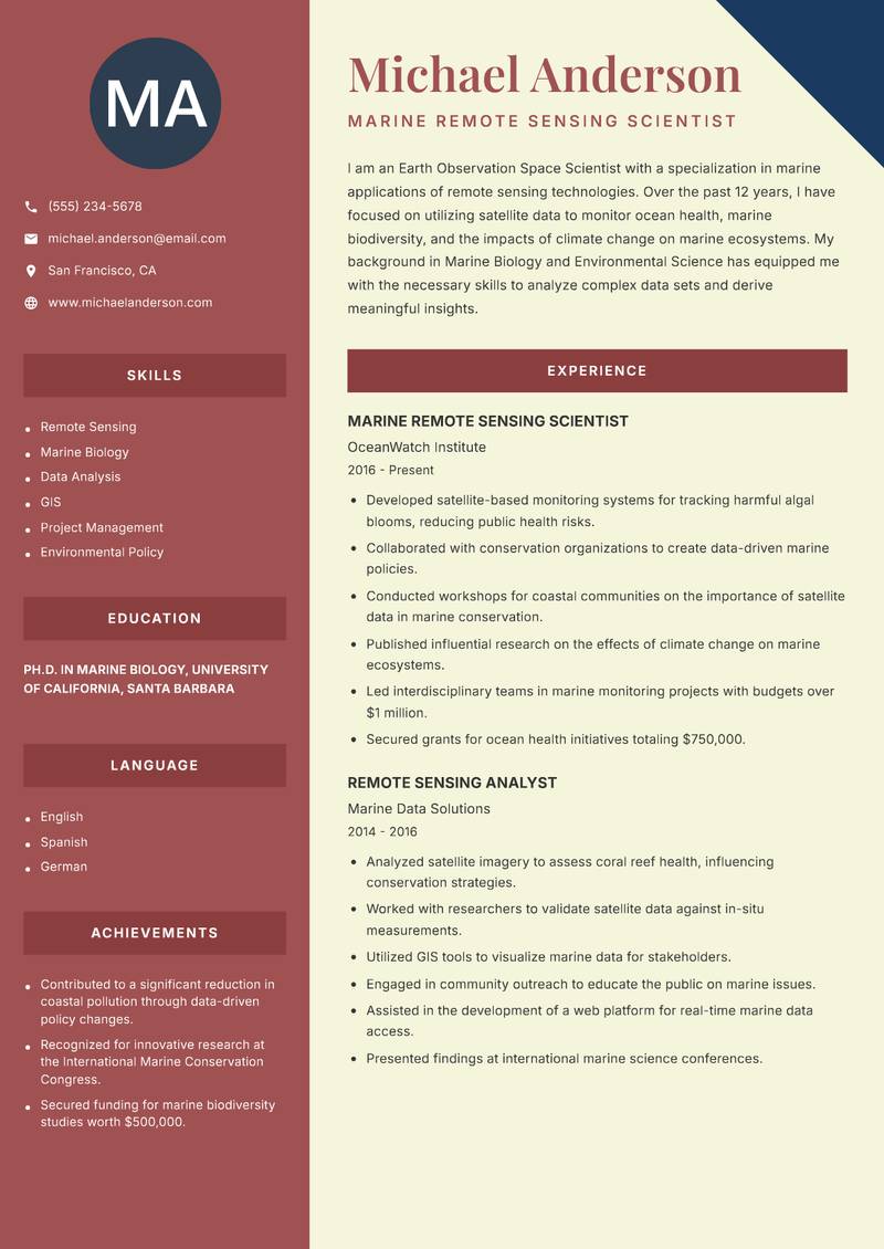
Two Column
Use Template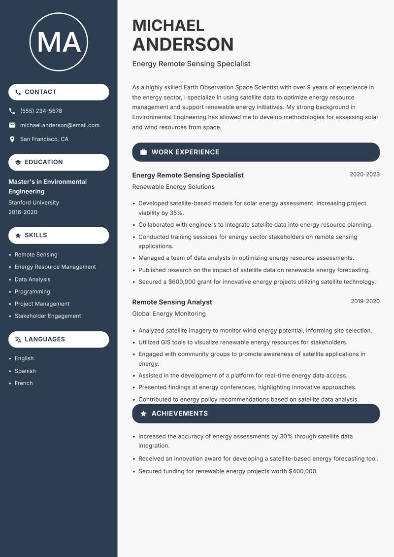
Compact
Use Template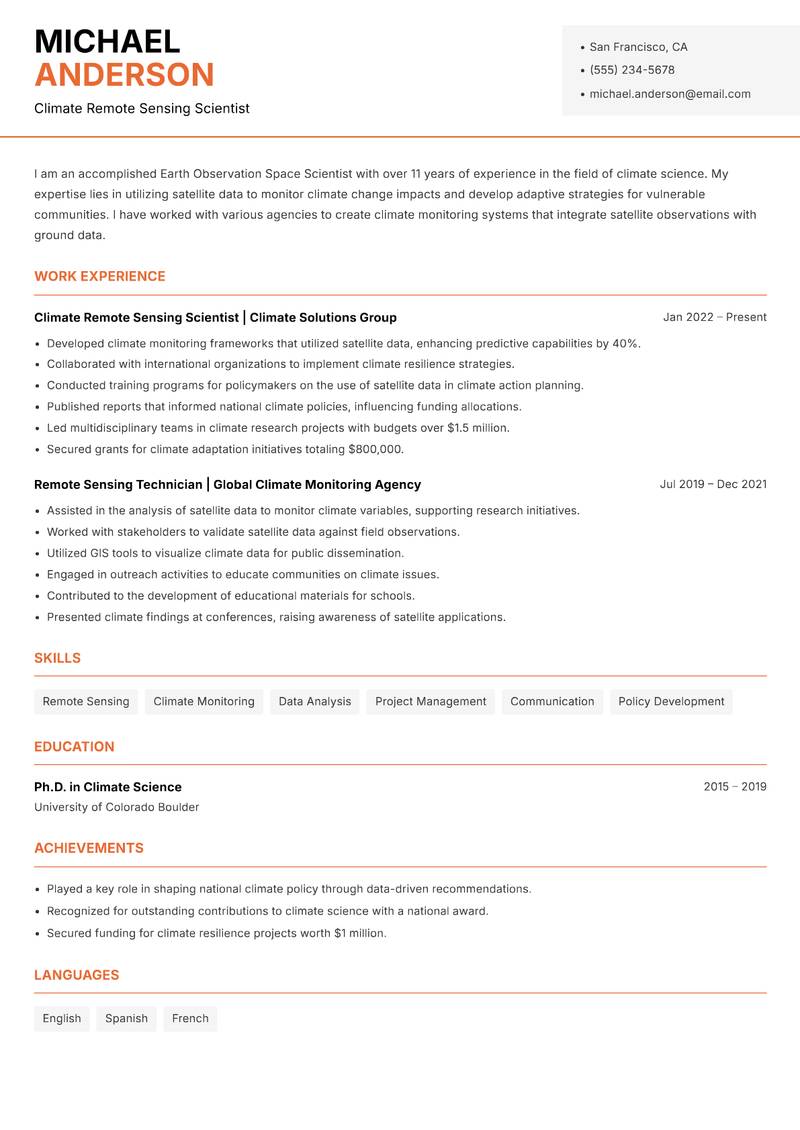
Modern Professional
Use Template7 Real Earth Observation Space Scientist Resume Examples
Senior Earth Observation Scientist with 10+ Years Experience
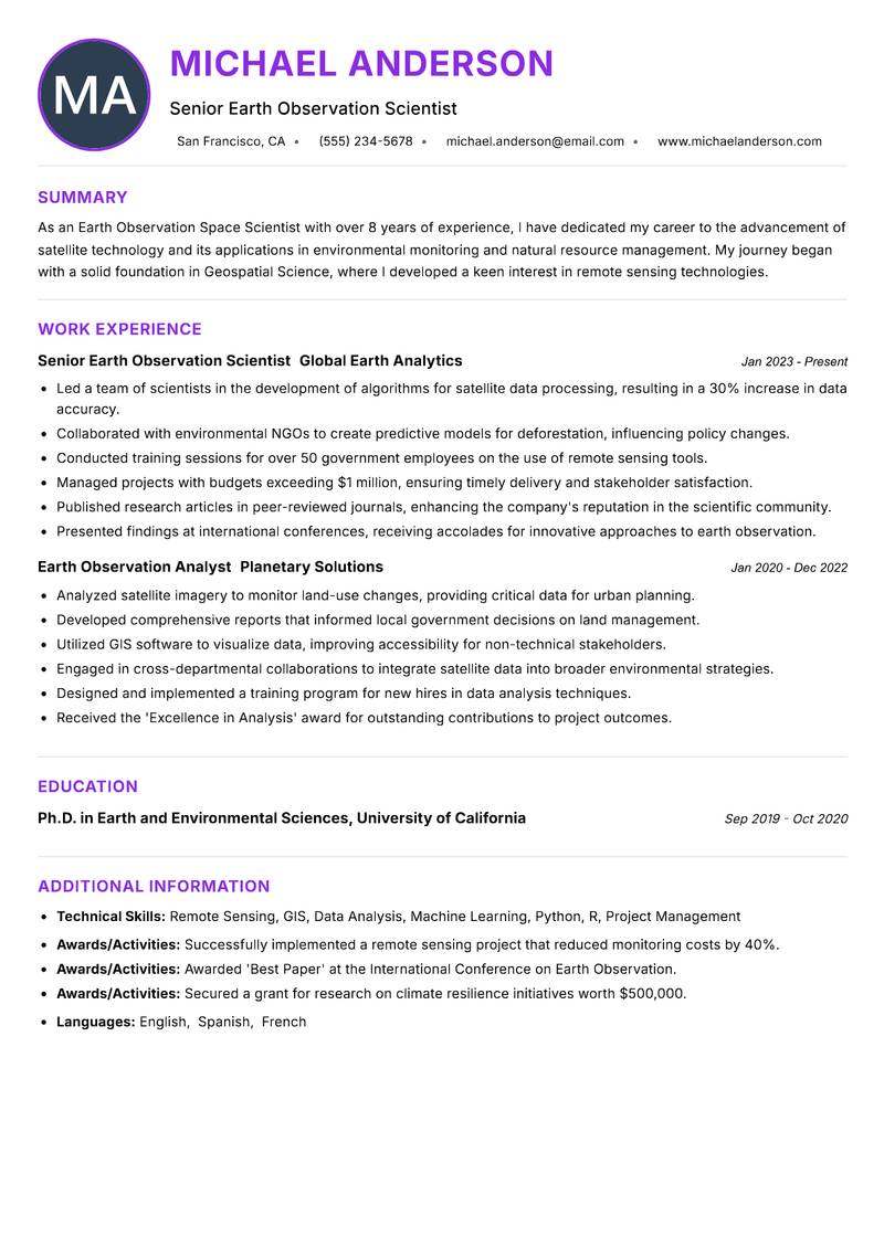
Summary: As an Earth Observation Space Scientist with over 8 years of experience, I have dedicated my career to the advancement of satellite technology and its applications in environmental monitoring and natural resource management. My journey began with a solid foundation in Geospatial Science, where I developed a keen interest in remote sensing technologies. I have worked extensively with various satellite data sources, including Landsat, Sentinel, and MODIS, to analyze and interpret earth data. My expertise lies in developing algorithms for image processing and machine learning applications to enhance data accuracy and utility. I have contributed to several impactful projects, including deforestation monitoring in the Amazon rainforest and urban heat island studies in metropolitan areas. My strong analytical skills and proficiency in programming languages such as Python and R have enabled me to lead teams in producing actionable insights for governmental and non-governmental organizations. I am passionate about using my skills to combat climate change and promote sustainable practices through innovative solutions in earth observation.
Description:
- Led a team of scientists in the development of algorithms for satellite data processing, resulting in a 30% increase in data accuracy.
- Collaborated with environmental NGOs to create predictive models for deforestation, influencing policy changes.
- Conducted training sessions for over 50 government employees on the use of remote sensing tools.
- Managed projects with budgets exceeding $1 million, ensuring timely delivery and stakeholder satisfaction.
- Published research articles in peer-reviewed journals, enhancing the company's reputation in the scientific community.
- Presented findings at international conferences, receiving accolades for innovative approaches to earth observation.
🏆 Key Achievements
Lead Earth Observation Scientist with 15+ Years Experience
Summary: With over 15 years of experience in Earth Observation and remote sensing applications, I have a proven track record in utilizing innovative technologies to address global challenges. Throughout my career, I have specialized in climate monitoring and disaster response, leveraging satellite data to support humanitarian efforts and policy development. My academic background in Environmental Science, paired with extensive field experience, allows me to bridge the gap between theoretical research and practical implementation. I have led numerous large-scale projects that utilize satellite imagery to assess natural disasters, track climate change impacts, and develop sustainable land management strategies. My strong leadership skills have enabled me to mentor junior scientists and foster collaborative environments among multidisciplinary teams. I am committed to advancing our understanding of earth systems and contributing to global sustainability initiatives through strategic use of satellite technologies.
Description:
- Oversaw a team of 20 scientists in satellite monitoring projects, enhancing data collection efficiency by 50%.
- Developed a real-time satellite data processing system that improved disaster response times.
- Partnered with international organizations to implement climate adaptation strategies.
- Initiated a mentorship program, resulting in a 40% increase in junior staff retention.
- Published influential papers on climate monitoring in leading scientific journals.
- Secured multiple funding sources for ongoing research projects totaling over $2 million.
🏆 Key Achievements
Earth Observation Specialist with 7+ Years Experience
Summary: I am a dedicated Earth Observation Space Scientist with a strong focus on agricultural applications of remote sensing technology. Over the past 7 years, I have specialized in precision agriculture, working closely with farmers and agronomists to optimize crop yields and enhance sustainable farming practices. My work involves analyzing satellite imagery to assess soil health, monitor crop growth, and identify areas at risk of pest infestations. I have developed user-friendly applications that allow farmers to access vital information in real-time, enabling them to make informed decisions. My background in Agricultural Engineering, coupled with my skills in data analysis and GIS, allows me to bridge the gap between technology and farming. I am passionate about empowering farmers with the tools they need to adapt to climate challenges while maximizing productivity. My goal is to continue leveraging satellite technology to transform the agricultural sector and promote food security.
Description:
- Designed algorithms to analyze satellite data for precision agriculture, improving crop yield predictions by 25%.
- Collaborated with agricultural experts to develop a mobile application for farmers to monitor crop health.
- Conducted training sessions for over 100 farmers on utilizing satellite data.
- Managed partnerships with agricultural cooperatives to enhance data sharing.
- Published case studies showcasing the impact of satellite technology on farming.
- Developed a dashboard for real-time monitoring of agricultural fields, increasing efficiency.
🏆 Key Achievements
Urban Remote Sensing Specialist with 10+ Years Experience
Summary: As an experienced Earth Observation Space Scientist, my focus is on urban applications of remote sensing technology, particularly in smart city development. Over the past 10 years, I have worked on various projects that utilize satellite data to analyze urban growth, infrastructure planning, and environmental impacts. My expertise lies in employing advanced analytical techniques to derive insights that support decision-making processes for city planners and governmental agencies. I have successfully led interdisciplinary teams, collaborating with engineers, urban planners, and policymakers to design sustainable urban environments. My educational background in Urban Studies and remote sensing has equipped me with the necessary skills to address complex urban challenges effectively. I am passionate about the future of smart cities and dedicated to using technology to enhance urban living conditions while addressing sustainability issues.
Description:
- Conducted urban growth assessments using satellite data, providing insights that informed city planning initiatives.
- Developed predictive models for urban heat islands, leading to a 20% reduction in energy consumption for cooling.
- Collaborated with local governments to implement satellite data in urban policy decisions.
- Led workshops to educate stakeholders on the benefits of remote sensing in urban development.
- Published findings in urban planning journals, raising awareness of satellite applications.
- Secured funding for urban sustainability projects totaling $1.2 million.
🏆 Key Achievements
Marine Remote Sensing Scientist with 12+ Years Experience
Summary: I am an Earth Observation Space Scientist with a specialization in marine applications of remote sensing technologies. Over the past 12 years, I have focused on utilizing satellite data to monitor ocean health, marine biodiversity, and the impacts of climate change on marine ecosystems. My background in Marine Biology and Environmental Science has equipped me with the necessary skills to analyze complex data sets and derive meaningful insights. I have collaborated with various governmental and non-governmental organizations to develop ocean monitoring programs that utilize satellite technology for real-time data collection. My passion for marine conservation drives my commitment to using satellite data to inform policies and practices that protect our oceans. I am dedicated to advancing marine science through innovative applications of Earth observation technologies.
Description:
- Developed satellite-based monitoring systems for tracking harmful algal blooms, reducing public health risks.
- Collaborated with conservation organizations to create data-driven marine policies.
- Conducted workshops for coastal communities on the importance of satellite data in marine conservation.
- Published influential research on the effects of climate change on marine ecosystems.
- Led interdisciplinary teams in marine monitoring projects with budgets over $1 million.
- Secured grants for ocean health initiatives totaling $750,000.
🏆 Key Achievements
Energy Remote Sensing Specialist with 9+ Years Experience
Summary: As a highly skilled Earth Observation Space Scientist with over 9 years of experience in the energy sector, I specialize in using satellite data to optimize energy resource management and support renewable energy initiatives. My strong background in Environmental Engineering has allowed me to develop methodologies for assessing solar and wind resources from space. I have worked on projects aimed at integrating Earth observation data into energy planning, enabling stakeholders to make informed decisions about resource allocation. My analytical skills, combined with my expertise in programming languages such as MATLAB and Python, have led to the successful implementation of data-driven solutions that improve energy efficiency. I am passionate about contributing to a sustainable energy future by leveraging technology and data analysis.
Description:
- Developed satellite-based models for solar energy assessment, increasing project viability by 35%.
- Collaborated with engineers to integrate satellite data into energy resource planning.
- Conducted training sessions for energy sector stakeholders on remote sensing applications.
- Managed a team of data analysts in optimizing energy resource assessments.
- Published research on the impact of satellite data on renewable energy forecasting.
- Secured a $600,000 grant for innovative energy projects utilizing satellite technology.
🏆 Key Achievements
Climate Remote Sensing Scientist with 11+ Years Experience
Summary: I am an accomplished Earth Observation Space Scientist with over 11 years of experience in the field of climate science. My expertise lies in utilizing satellite data to monitor climate change impacts and develop adaptive strategies for vulnerable communities. I have worked with various agencies to create climate monitoring systems that integrate satellite observations with ground data. My educational background in Climate Science and Environmental Policy has provided me with the foundational knowledge necessary to understand and address complex environmental issues. I am proficient in data analysis and visualization tools, allowing me to communicate findings effectively to diverse audiences. My commitment to climate resilience and sustainability drives my work, as I strive to empower communities with the information they need to adapt to a changing climate.
Description:
- Developed climate monitoring frameworks that utilized satellite data, enhancing predictive capabilities by 40%.
- Collaborated with international organizations to implement climate resilience strategies.
- Conducted training programs for policymakers on the use of satellite data in climate action planning.
- Published reports that informed national climate policies, influencing funding allocations.
- Led multidisciplinary teams in climate research projects with budgets over $1.5 million.
- Secured grants for climate adaptation initiatives totaling $800,000.
🏆 Key Achievements
Key Skills for Earth Observation Space Scientist
ATS Optimization Tips
Increase your chances of getting hired
Use Standard Headings
Use common section titles like Experience, Skills, etc.
Include Keywords
Add role-specific keywords from the job description
Keep it Simple
Avoid complex tables, images and graphics
Save in Right Format
Use PDF format unless otherwise specified
Earth Observation Space Scientist Salary Insights
Average Salary
$100,000
per year
Salary Range
$80,000 - $120,000
per year
Top Paying Cities
Los Angeles, Seattle, Houston, Dallas, Boston
Source: Glassdoor, Payscale, Indeed (Updated April 2025)
Everything you need to write a great Earth Observation Space Scientist resume
Strong Action Verbs to Use
Resume Writing Tips
- →Emphasize specific satellite systems and tools you have expertise in, as this is crucial for the position.
- →Detail your experience with data visualization and how you've communicated findings to stakeholders or non-technical audiences.
- →Highlight multidisciplinary projects, showcasing your ability to work across various scientific fields and data types.
- →Include examples of published research or presentations to illustrate your contributions to the field of Earth observation.
- →Mention any collaborations with government agencies or international organizations to underscore your network within the industry.
Common Mistakes to Avoid
- ✕Listing generic computer skills instead of specific software used in remote sensing and GIS.
- ✕Failing to quantify the impact of projects, like improvements in data processing efficiency or environmental monitoring accuracy.
- ✕Neglecting to tailor the resume to align with key responsibilities in Earth observation, such as data integration or satellite calibration.
- ✕Missing out on showcasing interdisciplinary collaboration experience, which is vital in this field.
ATS Keywords for Earth Observation Space Scientist
Earth Observation Space Scientist Career Path
Relevant Certifications
Career Progression
Entry-Level Earth Observation Analyst
Focuses on preliminary analysis and data processing of satellite imagery.
Mid-Level Earth Observation Scientist
Oversees project implementation, engages in advanced data modeling, and interprets complex datasets for scientific publications.
Senior Earth Observation Researcher
Leads research initiatives, publishes findings in peer-reviewed journals, and mentors junior scientists.
Earth Observation Program Manager
Manages team operations, funding proposals, and stakeholder relations, ensuring alignment with the organizational vision.
Principal Earth Observation Scientist
Sets research directions, collaborates with international space agencies, and drives technology development for cutting-edge applications.
Earth Observation Space Scientist Interview Questions
What satellite systems are you most experienced with, and how do you utilize their data in your work? +
Focus on specific platforms like NASA's Landsat series or ESA's Sentinel, detailing your experience with their data architecture.
Can you share an example of a complex dataset you analyzed and the insights you derived from it? +
Highlight the challenges faced and how your results contributed to environmental understanding or policy.
Describe a project where you applied machine learning techniques to Earth observation data. +
Mention specific algorithms used and the outcomes achieved through your analysis.
How do you ensure data integrity in your remote sensing analyses? +
Discuss methods for validation and quality assurance throughout your data collection and interpretation processes.
Have you worked in interdisciplinary teams? If so, how did you integrate different perspectives into your Earth observation research? +
Share experiences that illustrate how collaboration enhanced project outcomes.
What current trends in Earth observation excite you the most, and why? +
Reflect personal interests and how they may align with the organization's goals.
About the Earth Observation Space Scientist Role
Harnessing advanced satellite technologies, Earth Observation Space Scientists decode crucial planetary data into actionable insights for environmental and climate applications. Collaborating with governance bodies and research institutions, they analyze vast datasets such as multispectral imagery to track changes in land use, monitor natural disasters, and assess climate variability. Their expertise enables them to develop innovative methodologies and toolsets that interpret complex phenomena, promoting informed decision-making at both local and global scales.
Frequently Asked Questions
What types of tools do Earth Observation Space Scientists commonly use? +
They often use GIS software, remote sensing applications such as ENVI and ERDAS Imagine, and programming languages like Python for data manipulation.
Is a Ph.D. necessary to become an Earth Observation Space Scientist? +
While not always required, a Ph.D. is highly beneficial for advanced research roles and competitive positions in academic or governmental agencies.
What industries employ Earth Observation Space Scientists? +
They are typically found in environmental science, climate research, urban planning, and governmental space agencies.
How do I stay updated with developments in Earth observation technologies? +
Following scholarly journals, attending industry conferences, and being active in relevant professional organizations can keep you informed.
What impacts do Earth Observation Space Scientists aim to address? +
Their work primarily focuses on climate change, disaster response, land management, and resource sustainability.
More Resume Examples You Might Like
Related Career Paths
Other roles candidates for Earth Observation Space Scientist positions often also consider.
Will this Earth Observation Space Scientist resume pass the ATS scan?
Upload it and get an instant AI-scored compatibility check with specific fixes.
Check My Resume →
Pair it with a matching cover letter
AI drafts a first version from your job title and strengths — edit it live, then download the PDF.
Write My Cover Letter →
Written by Nohaya Career Team
Reviewed by HR Professionals · Updated April 2025
Ready to Build Your Perfect Resume?
Choose from 1000+ professional templates and land your dream job.
Create My Resume Now