Build an ATS-Friendly
Environmental Remote Sensing Scientist Resume
That Gets Interviews
The core functions of an Environmental Remote Sensing Scientist revolve around analyzing spatial data captured from aerial platforms and satellites. Insights derived from advanced remote sensing techniques influence environmental conservation strategies, assess ecosystem health, and guide land use planning.…
Environmental Remote Sensing Scientist Resume Templates
Modern Professional
Use Template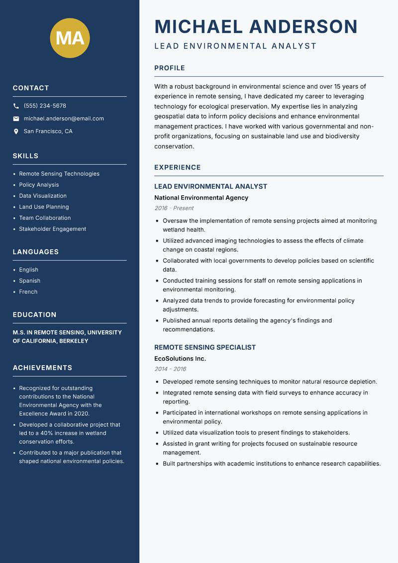
Classic Clean
Use Template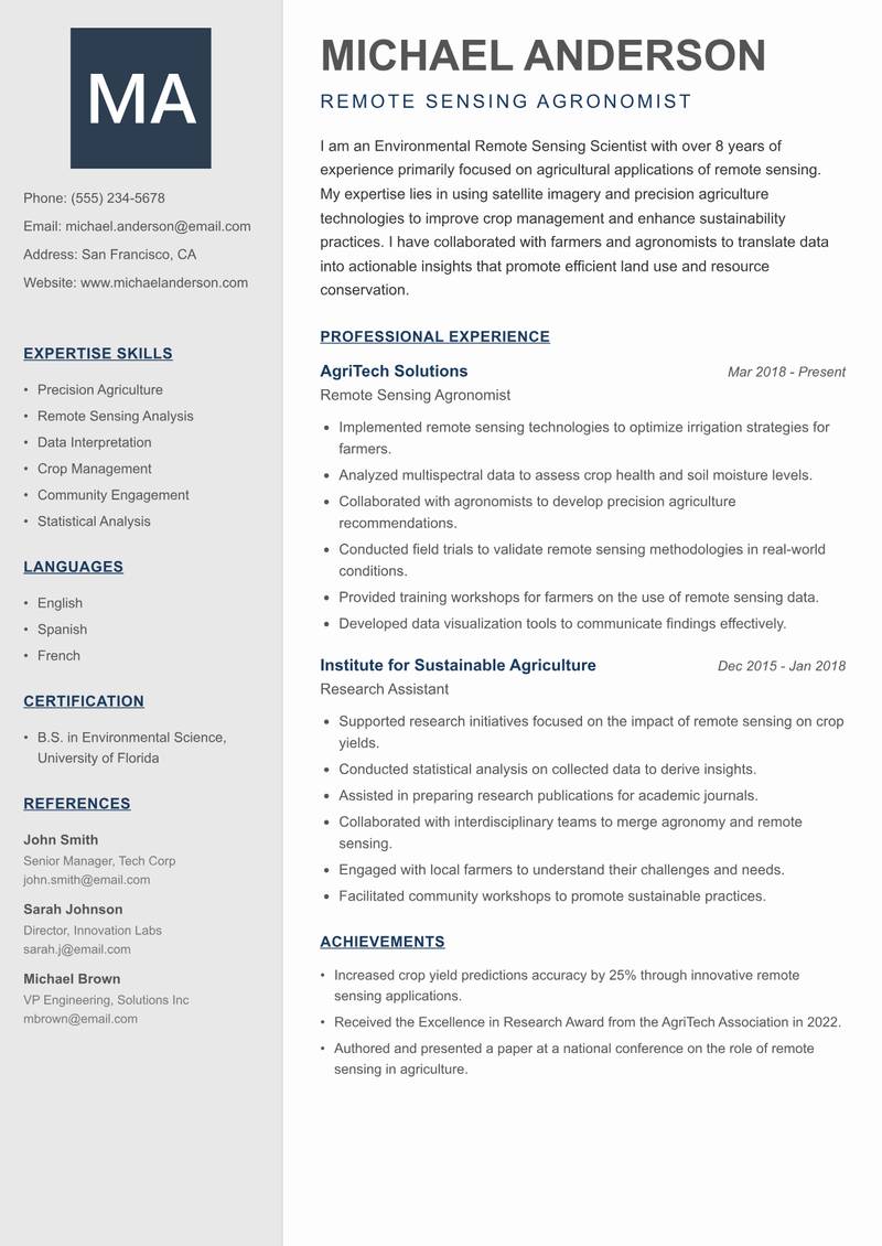
Creative Minimal
Use Template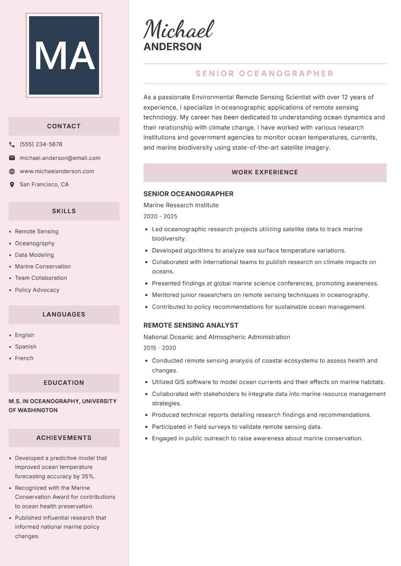
Executive
Use Template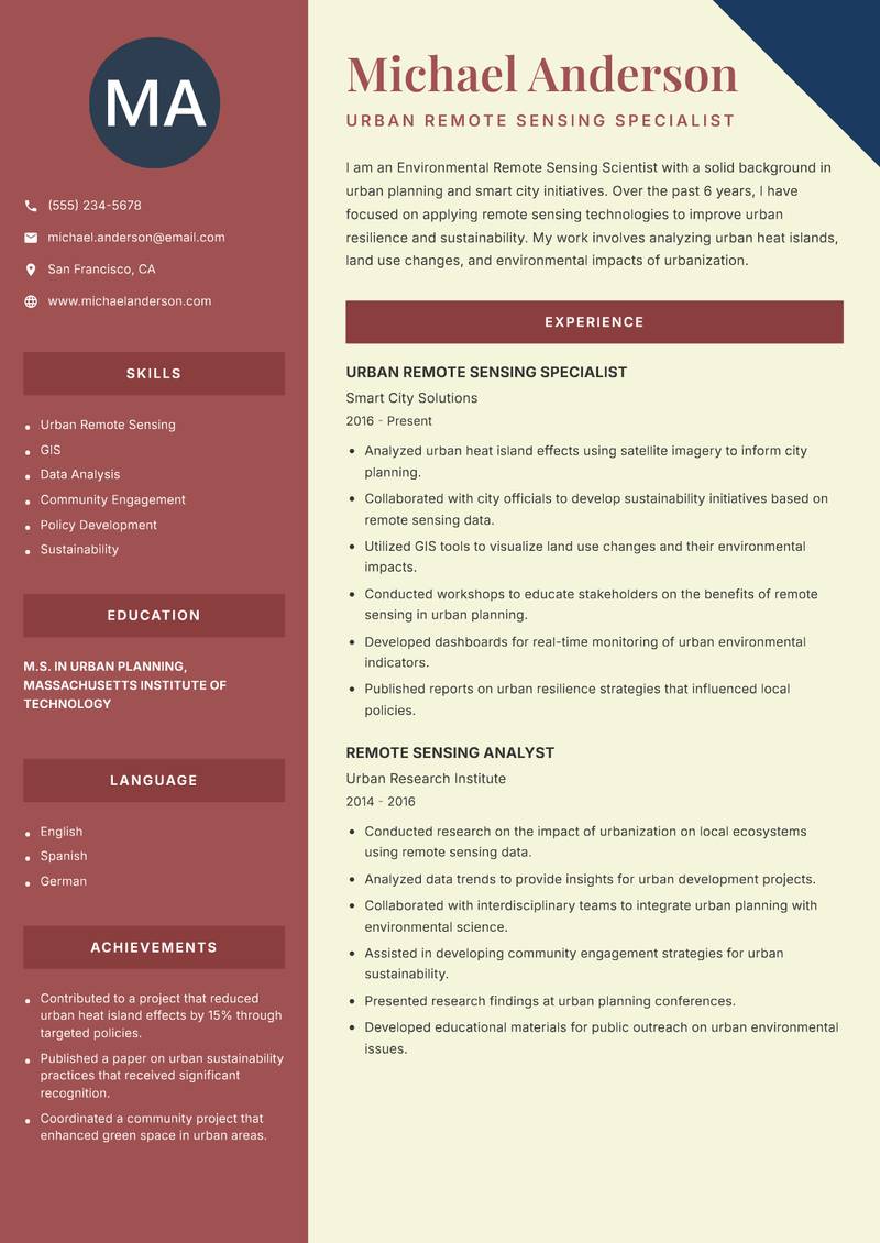
Two Column
Use Template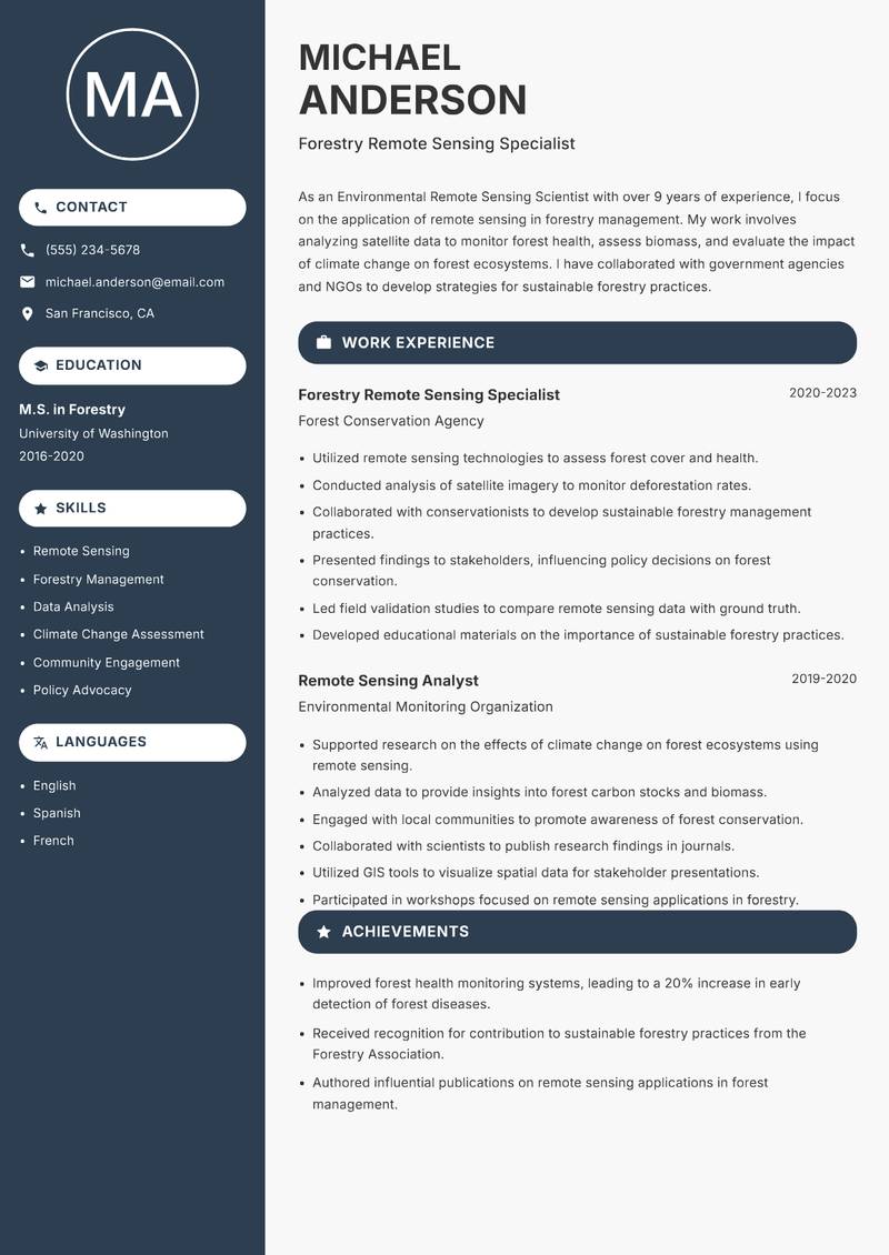
Compact
Use Template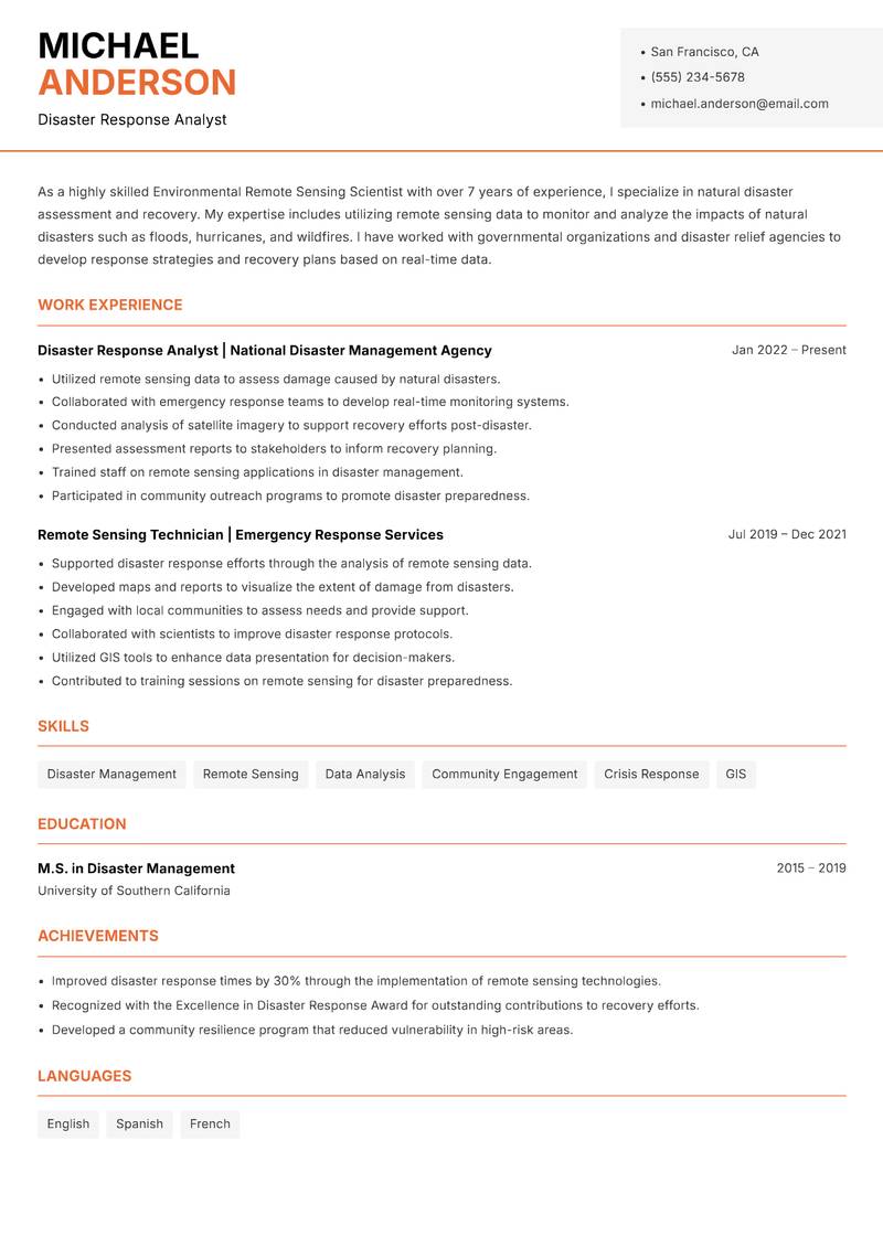
Modern Professional
Use Template7 Real Environmental Remote Sensing Scientist Resume Examples
Senior Remote Sensing Analyst with 10+ Years Experience
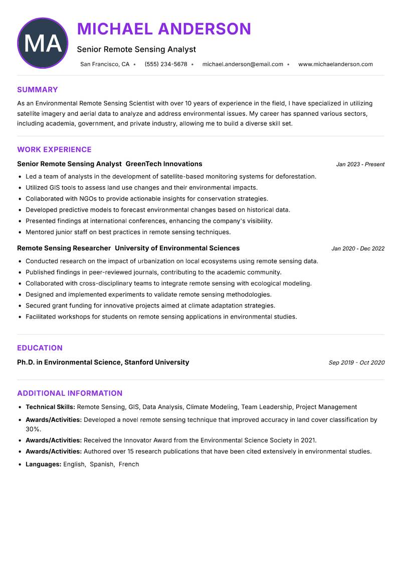
Summary: As an Environmental Remote Sensing Scientist with over 10 years of experience in the field, I have specialized in utilizing satellite imagery and aerial data to analyze and address environmental issues. My career has spanned various sectors, including academia, government, and private industry, allowing me to build a diverse skill set. I have successfully led multiple projects aimed at habitat conservation and climate change monitoring, employing advanced remote sensing technologies and methodologies. My strong analytical skills enable me to interpret complex data sets and convey findings to stakeholders effectively. Additionally, I am committed to collaborating with interdisciplinary teams to foster innovative solutions. My passion for environmental science drives me to continuously seek out cutting-edge research and development opportunities in remote sensing applications. I aim to leverage my expertise to contribute to sustainable practices that can mitigate environmental challenges and promote ecological balance.
Description:
- Led a team of analysts in the development of satellite-based monitoring systems for deforestation.
- Utilized GIS tools to assess land use changes and their environmental impacts.
- Collaborated with NGOs to provide actionable insights for conservation strategies.
- Developed predictive models to forecast environmental changes based on historical data.
- Presented findings at international conferences, enhancing the company's visibility.
- Mentored junior staff on best practices in remote sensing techniques.
🏆 Key Achievements
Lead Environmental Analyst with 15+ Years Experience
Summary: With a robust background in environmental science and over 15 years of experience in remote sensing, I have dedicated my career to leveraging technology for ecological preservation. My expertise lies in analyzing geospatial data to inform policy decisions and enhance environmental management practices. I have worked with various governmental and non-profit organizations, focusing on sustainable land use and biodiversity conservation. My analytical prowess combined with a deep understanding of environmental systems allows me to provide actionable insights that drive impactful environmental strategies. I am adept at using advanced remote sensing tools, including LiDAR and multispectral imaging, to assess environmental changes. My commitment to fostering collaboration between stakeholders ensures that I can effectively advocate for science-based solutions to complex environmental challenges. I continuously seek to expand my knowledge in this evolving field, aiming to contribute to innovative projects that address pressing ecological issues.
Description:
- Oversaw the implementation of remote sensing projects aimed at monitoring wetland health.
- Utilized advanced imaging technologies to assess the effects of climate change on coastal regions.
- Collaborated with local governments to develop policies based on scientific data.
- Conducted training sessions for staff on remote sensing applications in environmental monitoring.
- Analyzed data trends to provide forecasting for environmental policy adjustments.
- Published annual reports detailing the agency's findings and recommendations.
🏆 Key Achievements
Remote Sensing Agronomist with 8+ Years Experience
Summary: I am an Environmental Remote Sensing Scientist with over 8 years of experience primarily focused on agricultural applications of remote sensing. My expertise lies in using satellite imagery and precision agriculture technologies to improve crop management and enhance sustainability practices. I have collaborated with farmers and agronomists to translate data into actionable insights that promote efficient land use and resource conservation. My strong technical background allows me to effectively implement remote sensing tools and analyze data to improve yield predictions and manage agricultural risks. I am passionate about fostering relationships with farming communities and empowering them through data-driven decision-making. I continuously seek to innovate within the agricultural sector by integrating emerging technologies and methodologies. My goal is to contribute to a more sustainable food system through effective use of remote sensing technologies.
Description:
- Implemented remote sensing technologies to optimize irrigation strategies for farmers.
- Analyzed multispectral data to assess crop health and soil moisture levels.
- Collaborated with agronomists to develop precision agriculture recommendations.
- Conducted field trials to validate remote sensing methodologies in real-world conditions.
- Provided training workshops for farmers on the use of remote sensing data.
- Developed data visualization tools to communicate findings effectively.
🏆 Key Achievements
Senior Oceanographer with 12+ Years Experience
Summary: As a passionate Environmental Remote Sensing Scientist with over 12 years of experience, I specialize in oceanographic applications of remote sensing technology. My career has been dedicated to understanding ocean dynamics and their relationship with climate change. I have worked with various research institutions and government agencies to monitor ocean temperatures, currents, and marine biodiversity using state-of-the-art satellite imagery. My expertise in data analysis and modeling has allowed me to contribute significantly to marine conservation efforts. I am committed to using my skills to inform policy decisions on marine resource management and advocate for sustainable practices. I thrive in collaborative environments and enjoy working with diverse teams to tackle complex environmental challenges. My goal is to continue advancing the field of oceanography through innovative remote sensing techniques and contribute to global efforts in marine conservation.
Description:
- Led oceanographic research projects utilizing satellite data to track marine biodiversity.
- Developed algorithms to analyze sea surface temperature variations.
- Collaborated with international teams to publish research on climate impacts on oceans.
- Presented findings at global marine science conferences, promoting awareness.
- Mentored junior researchers on remote sensing techniques in oceanography.
- Contributed to policy recommendations for sustainable ocean management.
🏆 Key Achievements
Urban Remote Sensing Specialist with 6+ Years Experience
Summary: I am an Environmental Remote Sensing Scientist with a solid background in urban planning and smart city initiatives. Over the past 6 years, I have focused on applying remote sensing technologies to improve urban resilience and sustainability. My work involves analyzing urban heat islands, land use changes, and environmental impacts of urbanization. By utilizing satellite imagery and advanced analytics, I provide insights that aid in the development of smarter urban policies. I have collaborated with city planners and local governments to implement data-driven approaches to urban management. My skills in GIS and remote sensing allow me to visualize complex urban data and communicate findings effectively to diverse audiences. I am passionate about creating sustainable urban environments through innovative solutions that leverage technology and data analytics.
Description:
- Analyzed urban heat island effects using satellite imagery to inform city planning.
- Collaborated with city officials to develop sustainability initiatives based on remote sensing data.
- Utilized GIS tools to visualize land use changes and their environmental impacts.
- Conducted workshops to educate stakeholders on the benefits of remote sensing in urban planning.
- Developed dashboards for real-time monitoring of urban environmental indicators.
- Published reports on urban resilience strategies that influenced local policies.
🏆 Key Achievements
Forestry Remote Sensing Specialist with 9+ Years Experience
Summary: As an Environmental Remote Sensing Scientist with over 9 years of experience, I focus on the application of remote sensing in forestry management. My work involves analyzing satellite data to monitor forest health, assess biomass, and evaluate the impact of climate change on forest ecosystems. I have collaborated with government agencies and NGOs to develop strategies for sustainable forestry practices. My strong analytical skills and proficiency in remote sensing technologies enable me to provide valuable insights that support forest conservation efforts. I am passionate about utilizing my skills to drive initiatives that promote sustainable land management and biodiversity conservation. I thrive in collaborative settings where I can work with diverse teams to address complex environmental challenges.
Description:
- Utilized remote sensing technologies to assess forest cover and health.
- Conducted analysis of satellite imagery to monitor deforestation rates.
- Collaborated with conservationists to develop sustainable forestry management practices.
- Presented findings to stakeholders, influencing policy decisions on forest conservation.
- Led field validation studies to compare remote sensing data with ground truth.
- Developed educational materials on the importance of sustainable forestry practices.
🏆 Key Achievements
Disaster Response Analyst with 7+ Years Experience
Summary: As a highly skilled Environmental Remote Sensing Scientist with over 7 years of experience, I specialize in natural disaster assessment and recovery. My expertise includes utilizing remote sensing data to monitor and analyze the impacts of natural disasters such as floods, hurricanes, and wildfires. I have worked with governmental organizations and disaster relief agencies to develop response strategies and recovery plans based on real-time data. My strong analytical skills and proficiency in remote sensing technologies allow me to provide critical insights for disaster management. I am passionate about using technology to improve disaster preparedness and resilience in vulnerable communities. I thrive in high-pressure environments and am committed to ensuring that data-driven decisions are made in times of crisis. My goal is to continue advancing the field of disaster management through innovative remote sensing applications and contribute to building resilient communities.
Description:
- Utilized remote sensing data to assess damage caused by natural disasters.
- Collaborated with emergency response teams to develop real-time monitoring systems.
- Conducted analysis of satellite imagery to support recovery efforts post-disaster.
- Presented assessment reports to stakeholders to inform recovery planning.
- Trained staff on remote sensing applications in disaster management.
- Participated in community outreach programs to promote disaster preparedness.
🏆 Key Achievements
Key Skills for Environmental Remote Sensing Scientist
ATS Optimization Tips
Increase your chances of getting hired
Use Standard Headings
Use common section titles like Experience, Skills, etc.
Include Keywords
Add role-specific keywords from the job description
Keep it Simple
Avoid complex tables, images and graphics
Save in Right Format
Use PDF format unless otherwise specified
Environmental Remote Sensing Scientist Salary Insights
Average Salary
$97,500
per year
Salary Range
$75,000 - $120,000
per year
Top Paying Cities
Los Angeles, Seattle, Houston, Dallas, Boston
Source: Glassdoor, Payscale, Indeed (Updated May 2025)
Everything you need to write a great Environmental Remote Sensing Scientist resume
Strong Action Verbs to Use
Resume Writing Tips
- →Highlight proficiency with specific remote sensing software used in environmental analyses.
- →Emphasize collaborative projects with governmental agencies or NGOs where your remote sensing work made a significant impact.
- →Quantify outcomes of your analyses, like improvements in habitat conservation or reporting findings to stakeholders.
- →Showcase field experience in data collection using drones or ground-truthing methods to strengthen your resume.
- →Tailor your resume to reflect any specialized technical skills, like machine learning techniques for image processing.
Common Mistakes to Avoid
- ✕Listing generic software skills without detailing your proficiency in specialized programs like ENVI or QGIS.
- ✕Using vague terminology instead of concrete examples of past impacts on environmental projects.
- ✕Neglecting to mention specific remote sensing methodologies or techniques you have applied.
- ✕Failing to highlight the collaboration aspect with multidisciplinary teams.
ATS Keywords for Environmental Remote Sensing Scientist
Environmental Remote Sensing Scientist Career Path
Relevant Certifications
Career Progression
Entry-Level
Typically involves roles such as Field Technician or Junior Remote Sensing Analyst, focusing on data collection and preliminary analysis.
Mid-Level
Positions such as Remote Sensing Analyst or GIS Specialist, where the scientist interprets remote sensing data and begins to apply findings to environmental solutions.
Senior-Level
Roles like Environmental Remote Sensing Project Manager, overseeing projects, integrating data analysis with environmental policy, and managing teams.
Expert-Level
Consulting positions or Chief Scientists in environmental firms, contributing to major research initiatives and advising on remote sensing technology strategies.
Academic/Research-Level
Roles as a University Professor or Lead Research Scientist, focusing on advancing remote sensing methodologies and education in environmental sciences.
Environmental Remote Sensing Scientist Interview Questions
Can you explain a challenging project where you had to utilize remote sensing data to inform decision-making? +
Describe the project goals, the methods you used, and the outcomes achieved.
How do you ensure the accuracy and validity of your remote sensing data? +
Discuss specific techniques or tools that you regularly apply, such as quality assessment protocols.
Which types of satellite sensors have you worked with, and what were their specific applications in your previous roles? +
Be prepared to discuss various sensors and how they fit specific environmental projects.
What software tools do you prefer for remote sensing analysis, and why? +
Highlight your experience with tools like ENVI or ERDAS Imagine, and how they relate to specific tasks.
Describe a time when your remote sensing analysis impacted a conservation initiative or policy. What was your role? +
Focus on your contributions and the measurable outcomes that stemmed from your analysis.
What challenges do you foresee in integrating remote sensing data with traditional ecological methods? +
Show an understanding of comparative methodologies and interdisciplinary collaboration.
How do you stay updated on advancements in remote sensing technology? +
Mention specific journals, conferences, or professional organizations that you follow.
About the Environmental Remote Sensing Scientist Role
The core functions of an Environmental Remote Sensing Scientist revolve around analyzing spatial data captured from aerial platforms and satellites. Insights derived from advanced remote sensing techniques influence environmental conservation strategies, assess ecosystem health, and guide land use planning. Scientists often collaborate with government agencies and NGOs, translating complex data sets into actionable recommendations that align environmental stewardship with community needs.
Frequently Asked Questions
View all →What types of projects do Environmental Remote Sensing Scientists typically work on? +
They often work on projects related to land use change assessments, deforestation monitoring, and biodiversity tracking.
Is fieldwork a requirement for Environmental Remote Sensing Scientists? +
Yes, fieldwork is crucial for validating remote sensing data and ground-truthing analyses.
What is the importance of satellite imagery in environmental science? +
Satellite imagery provides critical insights that enable scientists to monitor changes over large areas, influencing policy and conservation efforts.
What background is necessary for a career in environmental remote sensing? +
A strong foundation in environmental science, geography, or computer science is essential, coupled with technical skills in data analysis.
Are there emerging technologies in remote sensing that are particularly influential in the field? +
Yes, advancements in drone technology and machine learning are transforming data collection and analysis methods.
What career advancements are typically available for an Environmental Remote Sensing Scientist? +
With experience, you may progress to project management roles or specialize in strategic consulting.
Do Environmental Remote Sensing Scientists work with other disciplines? +
Collaboration is common, as their data informs projects in hydrology, ecology, and urban planning.
More Resume Examples You Might Like
Related Career Paths
Other roles candidates for Environmental Remote Sensing Scientist positions often also consider.
Will this Environmental Remote Sensing Scientist resume pass the ATS scan?
Upload it and get an instant AI-scored compatibility check with specific fixes.
Check My Resume →
Pair it with a matching cover letter
AI drafts a first version from your job title and strengths — edit it live, then download the PDF.
Write My Cover Letter →
Written by Nohaya Career Team
Reviewed by HR Professionals · Updated May 2025
Ready to Build Your Perfect Resume?
Choose from 1000+ professional templates and land your dream job.
Create My Resume Now